Los Alazanes

Railroad tracks (looking southeast)

moon hesperia

Barker Rd / Fargo St (looking south)

Cedar Springs Dam

El Centro Rd / Barker Rd (looking northwest)

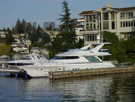
...anchored out here offseason...

Lytle Creek Valley

Off Roading in Cleghorn

Joshua Rd (looking east)

camino a L A

Cleghorn Pass

spillway from siphon

Joshua St / Barker Rd (looking south)

Joshua St / Braceo St (looking south)

Muscatel St / Anaconda Ave (looking south)

Dirt access road (looking north)

Aqueduct pipes

End of Trinity Rd (looking southeast)

Muscatel St / Alta Mesa Rd (looking south)

Braceo St (looking north)

The end of Oak Hill Ranch Rd (looking northeast)

roadrunner

Sunset @ Cleghorn on Historic 66 Cajon Pass CA

Neve nel deserto

Cedar Springs Spillway

District 8 NB 15, one mile south of Oak Hill Road, Nine slabs in the #4 lane

Silverwood Lake, Ca

Mount Cajon from Route 66 Cajon Pass CA

the Pinnacles

down the hill

Summit Valley

Clouds over San Bernardino mountains

Sawpit Creek

The Pinnacles

SR138 @ Cajon Pass

The old road

Drifting

Hesperia Airport, California, CA - USA (L26) [Oct 2012]

Hesperia Airport, California, CA - USA (L26) [Oct 2012]

Hesperia Airport, California, CA - USA (L26) [Oct 2012]

Silverwood BDT

Las Flores bridge

Marginal Way / Old Ranchero Rd (looking northeast)
Photos provided by Panoramio. Photos are under the copyright of their owners.