Saint Francis Xavier Cathedral in RABAUL, along MALAGUNA Road, in front of the North Daughter Volcano, near SIMPSON Harbour in ENBProv, PNG

Looking Down Old TUNNEL Hill Road to RABAUL in SIMPSON Harbour to TAVURVUR Volcano Venting Forth Steam and Ash over area, in ENBProv, PNG

Tavurvur Rabaul PNG 7/10/06

Eruption à Rabaul

Old Rabaul Airport,

Erupting volcano from beach

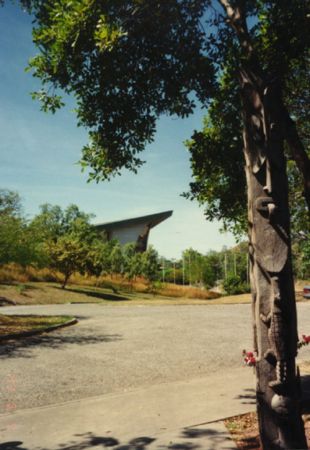
Old passenger terminal Rabaul Airport

WWⅡWreckage of bomber

RABAUL Volcano's in SIMPSON Harbour, taken from near BURMA Road Junction, with the DAWAPAI ROCKS on right in harbour, better known as The BeeHives, RABAUL, ENBP, PNG, on 3-12-2003

from above Malaguna area on hill near Catholic Church and School along Rabaul to Kokopo Road, near BURMA Road in Simpson Harbour, RABAUL, ENBProv, PNG, 1968

Tavurvur view from SW side

morning Devotions before start of work, at U.C. Building Dept, in MALAGUNA Block along Kokopo / Rabaul Road and Dowapai Street , in ENBProv, PNG, 1968

Rabaul vulcanos

View from Old China Town area in RABAUL near SULPHUR Creek, looking across to South Daughter [ TURAGUNAN ] Volcano Peak, next to Active MATUPIT Crater called TAVURVUR Volcano in MATUPIT Harbour area, in ENBProv, PNG, on 26-05-2007

DAWAPIA ROCKS, are old Volcanic Plugs in Simpson Harbour, with TAVURVUR Volcano and South Daughter Peak behind on left, These Rocks are more commonly known as The BeeHives, RABAUL, ENBP, PNG

Interior of The United Church of John Wesley, on MATUPIT Island, near RABAUL, ENBP, PNG, photo by Gideon Kakabin, on 17 November 2011

RABALANAKAIA Crater in front of The Mother Volcano, also known as KABIU, in Simpson Harbour, in RABAUL in ENBProv, PNG, in 1968

WW11 Captured Crane by Japs, towed here from Singapore and Sunk here by Allied Bombing, in KARAVIA Bay, along Rabaul to Kokopo Road near Blue Lagoon area, in ENBP, PNG, on 16-11-2003

Struggling Suviving COCONUT Palms on Side Slopes of RABALANAKAIA Yawning Crater in RABAUL, near Old China Town area and SULPHER Creek in SIMPSON Harbour, behind is The MOTHER Volcano Peak on right, in ENBProv, PNG

Tavurvur Volcano emitting Ash up over RABAUL area in ENBP, PNG, Photo by Jeffery Chan, in August 2011

Road to Volcanologist Observatory Lookout area from Tunnel Hill Road, North Coast Road, in ENBProv, PNB

SOUTH DAUGHTER [ Turagunan ] Volcano in BLANCHE Bay, viewed from on top of the Mother Volcano, Matupit Volcano on right side [ Tavurvur ] point on right across Simpson Harbour is RALUANA Village area, behind is GAZELLE Peninsula in ENBProv, RABAUL, PNG, 1967/68

The BEEHIVE Rocks, also known as DAWAPIA Rocks in SIMPSON Harbour, with RABAUL Volcano's behind MATUPIT Island beyond, in ENBP, By John Lau, on 13-12-2011

RABALANAKAIA CRATER in Old CHINA Town area near SULPHUR Creek in SIMPSON Harbour, in ENBProv, PNG

RABAUL UNITED CHURCH Ruins from 1994 Eruption of TAVURVUR Volcano, along Mango Avenue, [ now removed ], in ENBP, PNG, on 9-11-2003

From Simpson Harbour, looking towards Coconut Plantation that is next to RABAUL Airport on left, on right side is Causeway to MATUPIT Island, behind is TAVURVUR Volcano, also known as Matupit Crater, tall one behind is South Daughter [ Turagunan ], in ENBProv, PNG, 1968

View Looking down North side of Mother Volcano [ Kabiu ] this is the way up and Down on this Steep sides, well worth it on top, great views all round, in Rabaul in ENBProv, PNG, in 1967/68 Easter Trips

WATOM Island viewed from NONGA Hospital Beach area RABAUL, ENBP, February 2012

RAMARUTZ Workshop, in KARAVIA Bay, Buy now and save later, 2 for the price of 1, Order before its too late BEDS & COFFIN on SALE, ONLY in PNG, ENBP, RABAUL, on 23-11-2oo3

A Cloud passing over The Mother Peak Mount KOMBIU, with Yawning Rabalanakaia Crater and Palangiagia well Eroded Cone on right, with Old Matupit Crater better known as TAVURVUR Volcano in front of Mother Peak on right in BLANCHE Bay near RABAUL, Photo by S. Flinter, in ENBP, PNG, on 5-01-2012

RABAUL, Old China Town area along Sulphur Creek Road and Ah Chee Avenue, With Rabalanakaia Crater nearby, in ENBP, By John Lau, on 15-12-2011

Active TAVURVUR Volcano sending up Clouds of Ash heading towards KOKOPO area, with The Mother Peak on left and South Daughter Peak on right, taken from along Rabaul / Kokopo Road in KARAVIA Bay, in ENBP, PNG, on 13-11-2003

a WW11 Japanese Concrete Bunker surrounded by COCOA Trees near Vulan Crater in KARAVIA Village area near Karavia Bay, in ENBP, RABAUL, PNG, on 26-10-2003

South Daughter and Active TAVURVUR Volcano on other side of MATUPIT Harbour from old RABAUL Airport Runway, note Volcanic Rocks around area, thrown from volcano across harbour, Rabaul, ENBProv, PNG

View of RABAUL and SIMPSON Harbour area from NAMANULA Hill WW11 Memorial site, with Queen Elizabeth Park Sports Fields below in Devastated RABAUL, in ENBP, PNG, on 9-11-2003

Split Coconuts Drying on ground before While Flesh is removed for COPRA, at RALUANA near School along RABAUL to KOKOPO Road, in ENBP, PNG, on 25-11-2003

WW 11 MEMORIAL above RABAUL on NAMANULA Hill Road, in ENBP, PNG, on 9-11-2003

Rabaul / Kokopo Roads Restoration Project CULVERT being Constructed near DAVAON in KARAVIA Bay area, in ENBP, PNG, on 15-11-2003

Looking towards Active TAVURVUR Volcano Spewing Ash Skyways up over RABAUL town, in ENBP, PNG, on 18-10-2003

NONGA HOSPITAL Entrance area, with Old Nurses Quarters on left, along North Coast Road from RABAUL, in ENBP, By John Lau, on 29-12-2011

VULKANO RABAUL PNG

RABAUL, TAVURVUR Volcano Steaming during Morning across MATUPIT Harbour, near Causeway across to Matupit Island near Old Rabaul Airstrip in ENBP, By John Lau, on 23-08-2011

RABAUL Sun Set view from lookout area at Vunaulul above Davaon in Karavia Bay in ENBP in PNG, Photo by Esau Mellie on 5-06-2013

Local Village Garden area on ridge around Bitamapua U.C. in RALUANA area in ENBP in PNG, Photo by Esau Mellie on 24-06-2013

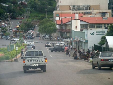
along Second 22nd Street and Page Street near Rabaul Market, Volcanic Ash from TAVURVUR covering Rabaul and MALAGUNA areas, in ENBP, PNG, on 31-10-2003

Active TAVURVUR Volcano covering the Mother Peak with Ash in RABAUL, with the South Daughter Peak on right at Entrance to Blanche Bay, photo taken from in KARAVIA Bay in ENBP, PNG, on 6-11-2003

SunSet from Nguvalian Beach in Karavia Bay along the Rabaul Kokopo Road in ENBP in PNG, Photo by Esau Mellie on 9-04-2013

United Church at MALAGUNA along Rabaul / Kokopo Road corner and Dowapia Street, with Gazelle Road Restoration Project Sign, in Rabaul area, ENBP, PNG, on 9-11-2003
Photos provided by Panoramio. Photos are under the copyright of their owners.